

East Antarctica often looks simple from above.
Extensive areas of ice cover the region, but a more complex picture lies beneath.
One feature stood out immediately. Several well-known subglacial basins appeared to be related to each other.
A mystery emerged because features that had been looked at individually were part of a much larger system.
The surprise was not that there were basins, but that they formed part of one interconnected system.
Rotational crustal stretching organized Antarctica’s hidden terrain
Continental crust has expanded away from the stable center, creating a fan-like pattern of basins. The process is known as distributed rotational extension.
As the crust stretched, triangular voids formed between the spreading segments.
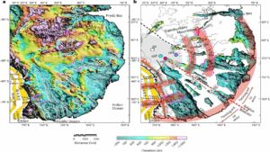
An open hand provides a useful comparison, with fingers spread apart creating gaps. These gaps reflect the new basins we have discovered.
The pattern is hard to attribute to chance, and features start to make more sense when looked at together.
Several major subglacial regions became part of one system
Several major sub-glacial regions can now be seen for the first time to be part of a continent-wide system.
A newly detected province consists of the Wilkes Basin, Aurora Basin, and Lake Vostok basin and constitutes the East Antarctic Fan-shaped Basin Province.
The study looked at the entire system rather than individual elements. Its large scale and obscuring ice made it difficult to recognize as a single system.
Independent datasets revealed the same underlying pattern
Some of this province is under more than 3km of ice, which instantly shows how difficult it is to observe features.
Topography, geological features, gravity readings, magnetic surveys, seismic records, and lithospheric models were compared, as described by Durham University.
The comparison revealed a coherent fan-like system, according to findings published in Nature Geoscience. None of these individually could determine the entire geometry.
Having many of the datasets match makes this more reliable, and different methods of interpreting the measurements have led to the same result.
The actual landscape remains hidden, so interpretations still rely on indirect data.
Large parts of the landscape remain hidden
Much of this structure is blocked by ice, meaning large areas have to be interpreted. So, scientists use a variety of geophysical methods to pick up on different aspects.
No one technique can show us everything, so using a combination of approaches can help overcome this.
Reconstructed landscapes still contain uncertainties, as key details can be lost through missing data.
Rebounding the topography has helped overcome some of these issues. That approach allows estimates of what the landscape would look like without the ice.
Ancient terrain continues shaping modern ice flow
The basic shape of the bedrock is still affecting the ice flow.
Lakes and basins are not in random positions because they follow the shape of the bedrock.
Bedrock still influences the ice. Ice responds to the landscape.
Some areas may be more susceptible to environmental change, as conditions beneath the ice can affect their stability. Ancient tectonic features may also play a role.
Some of the biggest unanswered questions remain
The biggest uncertainty is the age, as we do not know exactly how old the province is. Many tectonic events may have played a role in forming the province.
Possible links to Gondwana and the separation of Australia from Antarctica remain under investigation.
Untangling this will not be straightforward, as there may be several events recorded in one structure.
There are still questions about the deeper causes. The lithosphere may still hold the answers, but we cannot fully work this out from our datasets.
Read the whole thing?
Get the week's signal, not the noise
Our sharpest reporting on energy, climate and nature — free, once a week.


