For more than a thousand years, people have traveled to witness the annual spectacle of leaves turning red and gold — from Japan’s ancient practice of momijigari, or “red leaf hunting,” to New England’s modern leaf-peeping season. That ritual now has an unexpected participant.
NASA’s PACE satellite, equipped with its hyperspectral Ocean Color Instrument, scans the planet’s vegetation every single day. For the first time, it can track all three key fall foliage pigments — the reds, yellows, and greens — simultaneously, across the entire Earth.
A satellite joins a thousand-year-old tradition
Japan’s momijigari tradition stretches back over a millennium, documented in ancient poems describing journeys made to admire fall color. In 19th-century America, artists like Frederic Church painted the blazing Northeast, and poets like Emily Dickinson found language for the season’s particular light. Leaf-peeping became a cultural institution long before it had a name.
PACE is now part of that lineage. Its Ocean Color Instrument, or OCI, was originally designed to study ocean ecosystems — yet its 286 spectral bands also capture subtle shifts in land vegetation, scanning the full planet every single day. No human observer, no network of ground stations, comes close to matching that scale.
Reading color from orbit: the three pigments that matter
Every fall color you see in a forest traces back to one of three pigment groups. Anthocyanins produce the reds, carotenoids generate yellows and oranges, and chlorophylls give leaves their green. As temperatures drop and days shorten, chlorophyll breaks down, letting the other pigments emerge.
What makes PACE different is scope and frequency. Other hyperspectral satellites can measure all three pigments, but only over localized areas and less often. PACE is the first capable of measuring anthocyanins, carotenoids, and chlorophylls across the entire planet every day or two.
Vegetation scientist Karl Huemmrich, of the Goddard Earth Sciences Technology and Research II center at the University of Maryland, Baltimore County, put it plainly: “It’s the ability to collect time-series data of anthocyanins and carotenoids everywhere on Earth repeatedly that is game-changing.”
Waves of red: what the maps revealed this fall
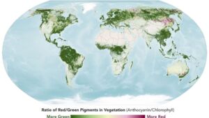
The redness maps PACE produced this fall show the season moving like a slow tide. In late September, intense reds appeared first across northern Russia, northern Alaska, and northern Canada. By early October, that wave shifted south into New England and upstate New York, then spread into the Midwest and Mid-Atlantic.
The Adirondacks, Vermont’s Green Mountains, and New Hampshire’s White Mountains all registered high redness — driven largely by sugar maples and red maples. On October 3, Landsat 9 captured a striking image of intensely red foliage around Ripton, Vermont, near peak color season. It’s the same town where Robert Frost kept a summer home and taught at Middlebury’s Bread Loaf School of English.
Beyond beauty: what fall color tells scientists about Earth
Pigment shifts can also signal that vegetation is under stress — from drought, insect damage, or disease. This fall, PACE detected anomalously high redness in agricultural regions of Brazil, Australia, and Canada. NASA data scientist Skye Caplan noted these signals likely reflect stressed or harvested crops rather than autumn foliage.
Scientists hope PACE data will shed light on how the timing of spring greening and fall senescence is shifting — and how those changes affect the global carbon cycle, leaf color’s influence on wildfire risk, and more. The satellite may also serve as an early warning system for drought, insect infestations, and plant disease: a range of threats that ground-based monitoring alone can’t track at planetary scale.
Citizen scientists help ground-truth the view from space
Satellites see a lot, but they can’t see everything. As part of the North American Phenology Campaign run by the GLOBE program, Caplan has been posting weekly foliage maps showing waves of redness moving southward through the season. The PACE team is asking anyone who can photograph vegetation to submit images — helping scientists ground-truth what the satellite observes from orbit.
Shrubs, grasses, crops, wildflowers, evergreens — all of it is useful. As PACE continues collecting daily data, its value will compound, building a long-term, planet-wide record of how vegetation responds to a changing climate. As Caplan put it: “Color changes happen kind of slowly, then all at once, and then they’re gone.”
Read the whole thing?
Get the week's signal, not the noise
Our sharpest reporting on energy, climate and nature — free, once a week.