

On October 12, 2026, Manaus went dark in the middle of the day. Thick smoke from fires burning across the surrounding rainforest blanketed the city of more than 2 million people, pushing PM2.5 air quality readings above 135 micrograms per cubic meter — deep in the hazardous range. Schools closed. Citywide events were canceled. Children’s sports leagues went quiet.
For scientists who study how El Niño reshapes fire patterns across the tropics, none of this came as a surprise. They’d been watching it build for months.
A city smothered in smoke
NASA’s Aqua satellite captured the scene on October 12, 2026: smoke poured from fires on both sides of the Amazon River, converging over Manaus in a thick, gray blanket. The MODIS instrument recorded PM2.5 readings above 135 micrograms per cubic meter — the second-worst rating on the regional air quality index. The World Health Organization’s safe daily limit sits at 15.
The fires near Manaus and the nearby city of Santarém aren’t isolated incidents. Scientists describe them as the early, visible edge of what they expect to be a long and severe season — one that follows a pattern they’ve documented before.
The domino effect El Niño sets in motion
Douglas Morton, an Earth system scientist at NASA’s Goddard Space Flight Center, uses the word “cascade” to describe what El Niño does to fire patterns across the tropics. It starts in Indonesia, where drought dries out peat-rich forests and ignites massive fires. Weeks or months later, the same disrupted rainfall patterns reach the Amazon — and the second domino falls.
Morton and colleagues from the University of California, Irvine; Vrije Universiteit Amsterdam; and the University of Maryland first detailed this cascade in a 2017 Nature Climate Change study, analyzing the destructive 2015–2016 El Niño season. The same sequence repeated in 2023.
In 2026, the pattern has followed the same script. Since August, drought, fire, and smoke have smothered parts of Indonesia — hundreds of homes razed, whole islands blanketed in haze. “Now, in the Amazon, we’re seeing the second domino in the cascade fall,” Morton said. The fires currently burning began as routine land-management burns that this year’s drought turned into something much harder to contain.
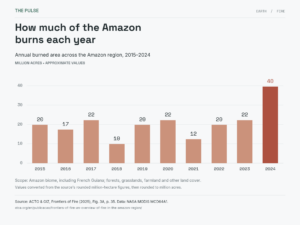
Why this year’s drought is especially dangerous
The rainfall numbers tell a clear story. Brazil’s National Institute of Meteorology reported that Manaus received 95% less rain than normal in August 2026, and 60% less than normal in September. That level of dryness transforms a landscape normally too wet to burn easily. Remarkably, lightning starts less than 1% of Amazon fires — almost everything burning right now was ignited by a person, meaning much of this destruction was preventable.
What makes 2026 particularly concerning is the overlap with previous fire years. Many forests now burning also burned during the 2015 and 2023 El Niño events, leaving trees partially charred and weakened. When fire returns to already-damaged forest, the ecological toll compounds — and most Amazonian species have no evolutionary adaptation to fire, making repeated burning especially destructive for ecosystems that may not recover between cycles.
Satellites are missing more fires than officials realize
The official fire counts are already alarming. But Shane Coffield, a University of Maryland assistant research scientist working at NASA Goddard, suspects the real picture is worse. He’s mining data from the VIIRS satellite instrument to identify fires that didn’t meet the detection threshold for NASA’s standard FIRMS data products.
His preliminary findings are striking. “For the area around Santarém, we’ve identified about 40 percent more fires than you’ll see in active fire counts from FIRMS,” Coffield said. Dense smoke, cloud cover, and forest canopy all interfere with infrared sensors — particularly for lower-intensity fires creeping through the understory. Coffield plans to share these “candidate fire” locations with MapBiomas, a multi-institutional network of universities, NGOs, and technology companies that tracks fires and land-use change across the Amazon.
Where the fire front is heading — and when
The fires around Manaus and Santarém are expected to keep burning until the rainy season returns, likely in December 2026 or January 2027. Come November and December, Morton and his colleagues project elevated fire risk in the Brazilian states of Roraima, northern Pará, and Amapá, as well as parts of Venezuela, Guyana, and Suriname.
Drought and fire risk are expected to peak across the southern Amazon regions of Brazil and Paraguay around August and September 2027 — communities that still have time to prepare. Morton’s message for those regions is direct: “Given the intensity of this El Niño, this really is the year for people to avoid burning at all costs.” The cascade isn’t finished, and the question now is whether that knowledge translates into action before the next wave arrives.
Read the whole thing?
Get the week's signal, not the noise
Our sharpest reporting on energy, climate and nature — free, once a week.


